Effortless Slippage: Cartographies of the Networked World
Ingrid Burrington
For about as long as there has been a networked world there have been people adorning it with the accessories and ephemera of the nation-state. Some of these gestures were more of a literal attempt to translate the borders of the world onto the net, such as ARPANet legend Jon Postel’s decision to assign two-character ISO country codes to every nation as top-level domains. Postel assumed a future of domain names functioning more like folder directories or physical mailing addresses—the website of IBM offices in Armonk, New York, might live at “IBM.Armonk.NY.US”—rather than the linguistic hacks and poetics they’re used for now.1
But perhaps the more familiar nation-state accouterment applied to the internet is the rebellious manifesto. The most literal and famous of these is J. P. Barlow’s 1996 “Declaration of the Independence of Cyberspace,” which borrowed the rhetoric of Jeffersonian outrage to situate the net as beyond the purview of governments.2 If the network-as-nation had a fundamental character in the early days of the internet, it was an outlaw one—where Barlow and the cowboys of cyberspace could declare independence from the dunces of Davos, a Wild West conveniently lacking in genocidal baggage from the last time Americans attempted to manifest their destiny (though still infused with Orientalist aesthetics in cyberpunk culture). This Wild West was only stealing control away from fuddy-duddy benevolent technocrats like Postel and the ARPAnauts, the federally funded squares who laid the foundation but lacked the cowboy’s imagination.
Regardless of whether the network was viewed as a tidy technocrat state or an unruly terrain of rebels, both versions needed their own mappa mundi. This is perhaps the most obviously necessary artifact of a would-be sovereign—stamps or seals (in tech, manifest in the litany of company and conference logo stickers festooning hacker laptops) and declarations of independence can instill pride or cultivate a sense of identity, but citizens of a collective imaginary need a place to imagine. Additionally, sovereigns like being able to visualize their terrain and, by extension, the scope of their power. The historical maps made of the internet—and, later, the maps of the world made by the internet—are both reflection and instrument of the ideologies and entanglements of the networked world. They are one way we might navigate the premise of the networked citizen and her obligations to her fellow travelers in the networked landscape.
The early ARPANet maps aimed for at least some geographic accuracy when there weren’t too many nodes—SRI, UCSB, UCLA, and Utah are more or less in the correct locations against a void USA in 1969 maps. But as new nodes accumulated (mostly along the coasts), our network cartographers switched to a logical map that eschewed gestures at geography and had more resemblance to a circuit diagram.
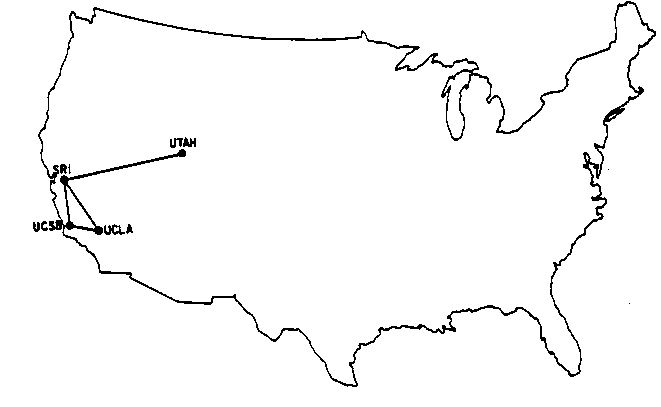
ARPANet map, 1969. © Advanced Projects Research Agency
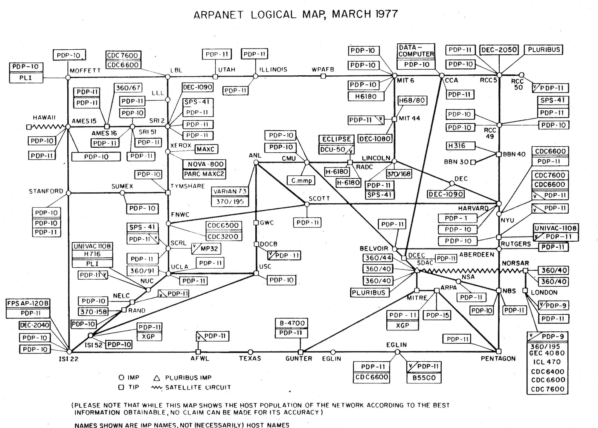
ARPANet map, 1977. © Advanced Projects Research Agency
This form would be echoed by maps like the “Internet Road Map” included as a supplement to MacUser magazine around the same time that Barlow issued his secessionist jeremiad. The map divided up the 1996 internet into “zones” depending on interests—there are zones of “government information,” “education and reference,” “internet reference,” “business and commerce,” “Macintosh resources,” and “arts and humanities.” From the center point of the “MacUser Web,” readers could chart a path to one of the five US states with a website (at that time, California, Washington, Minnesota, Oregon, and Texas) or some of its quainter entries such as a “graphics-intensive, thorough frog dissection tutorial with lots of images and movies.” Its listings also invoke spatial metaphors, such as “The Internet Mall” and “The Electronic Newsstand.” Skeuomorphism of this kind is hardly a novelty in the realm of personal computing. It’s a deliberate, and arguably necessary, strategy for beckoning new settlers. As infrastructure began to tame the so-called wild frontier of the web, novice homesteaders arrived to an increasingly settled terrain full of fun, convenient, prefab architecture. All they had to do was select which fanciful neighborhood of GeoCities (which literally referred to their users as “homesteaders”) spoke to their desires.3 Not everyone wants to be an outlaw; some people just want to settle down in EnchantedForest with their gifs and blink tags.
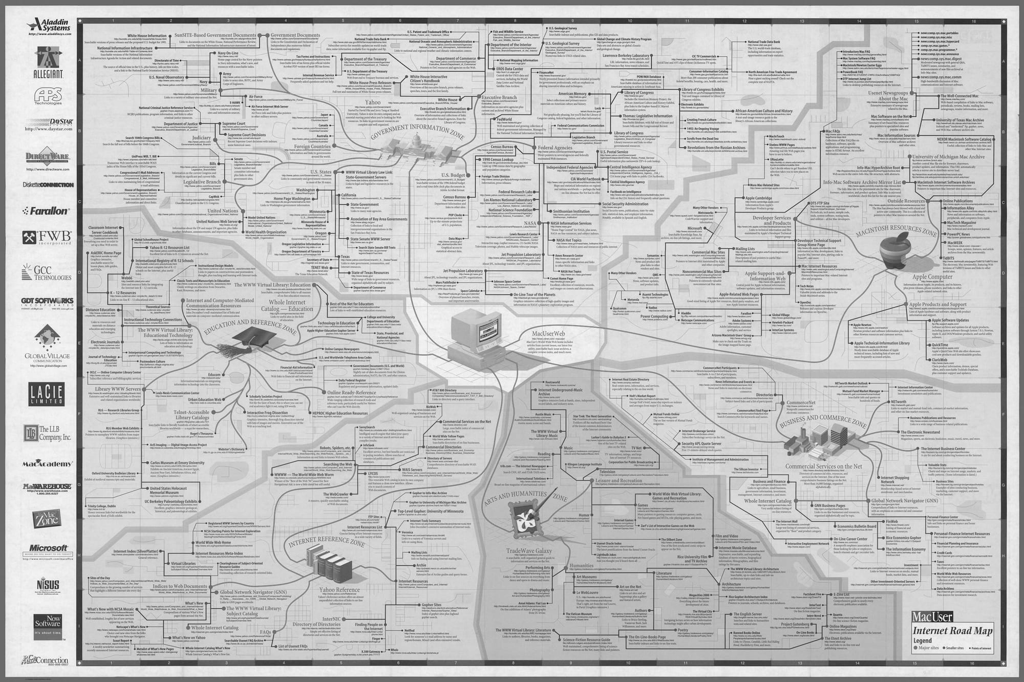
MacUser Internet Road Map, 1996.© David Rumsey Map Collection
The MacUser zones suggest a better metaphor for the internet as sovereign body—not as nationstate or wild frontier but more like a constellation of special economic zones. The internet is full of sites of exception carved out by nation-states, ostensibly in the service of innovation and commerce, but in practice an easy recipe for labor exploitation and corruption. But the early web of MacUser zones felt more like makeshift railroad company towns waiting to see if the water would run out than the monoliths of Shenzen or Dubai.
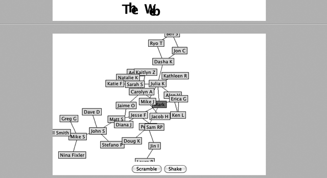
Screenshot of The Web on Mark Zuckerberg’s first website, 1999.
One can, of course, find hints of the future networked regime to come in the archaeology of the old web. In 2013, a Hacker News poster discovered what appeared to be Mark Zuckerberg’s first personal website (hosted, somewhat surprisingly, on Angelfire).4 The site has since been purged, but lives on in screenshots and on the Internet Archive.5 While the clumsy jokes and coding experiments of an awkward fifteen-year-old boy might only be revelatory in that they suggest that Zuckerberg is, in fact, human, one page stands out. Young Zuckerberg made a Java applet for his site called “The Web,” which appeared to be a network diagram mapping Zuckerberg’s personal connections and his friend’s extended connections—in short, a social graph. Fifteen-year-old Zuckerberg described it thusly:
As of now, the web is pretty small. Hopefully, it will grow into a larger web. This is one of the few applets that require your participation to work well. If your name is already on The Web because someone else has chosen to be linked to you, then you may choose two additional people to be linked with. Otherwise, if you see someone who you know and would like to be linked with but your name is not already on The Web, then you can contact me and I will link that person to you and put you on The Web. If you do not know anyone on The Web, contact me anyway and I will put you on it.
While it’s unlikely that his Angelfire website was at the forefront of Zuckerberg’s mind when creating Facebook years later, it’s sort of reassuring to know that the impulse to index, map, and sort human beings like nodes in the ARPANet goes further back than the hokey mythos of the jilted freshman or the flash of genius ascribed by cinema and hagiography.
Facebook is the company that seems most easy for people to see like a state; since Rebecca MacKinnon’s first coining of “Facebookistan” in Consent of the Networked, the nickname has been used by dozens of journalists and at least one made-for-television Danish documentary.6 It’s catchier than MacKinnon’s other sovereign example “Googledom” (which sounds kind of like a painfully banal kink), and Facebook leans into the nation-state comparison more explicitly in its constant invocation of “community” and appropriation of democratic movements to serve its IPO. But in trying to pinpoint the moment when the collapse of boundaries between networked zones and nation-states occur, we need to return to cartography (and we will, via cartography, return to that fish in a barrel Zuckerberg). Although social media undoubtedly facilitated a sea change in public understanding of the false dichotomies of online and IRL, a more literal transformation emerged with the launch of Google Maps. In this moment, the network became the vantage point for mapping the world. In so doing, it became a means through which the network could perpetually mediate the world while the network itself became harder and harder to map and comprehend.
Of course, there were prior mapping services online, but Google Maps introduced two crucial technical innovations that would transform both the way that internet users saw the world and, eventually, how they moved through it. The first technical shift popularized by Google Maps was the map tile. Earlier web mapping services were a bit more like desktop GIS software: zooming in or panning across the map reloaded the entire webpage with a new image. The tiled web map is a collection of thousands of 256 × 256-pixel-sized images of the world at different zoom levels. As a user zooms or pans across a tiled map application, the page sends a request to a server for new tiles, refreshing on the fly with lots of tiny images instead of waiting for one enormous image to load. Making these server requests required the use of AJAX (Asynchronous Javascript and XML) requests in the background, which was at the time a new and experimental technical framework for running code, but would soon become the backbone of the increasingly real-time web. Google Maps didn’t invent AJAX so much as find a clever use for it and contributed to its popularization across the web. It’s AJAX that made that rapid reload of your News Feed possible, that renders news sites into something like abandoned Josef Albers compositions of various rectangular color fields while a server fetches article text, that makes it trivially easy for tracking software to capture your every move and click on a website in real-time and pass it along to advertisers. It also means that Google can rapidly send information like your location back to a server and, based on that information, choose which version of the world to show you. Depending on where you’re viewing the map, the Crimean Peninsula may or may not be a secessionist region.
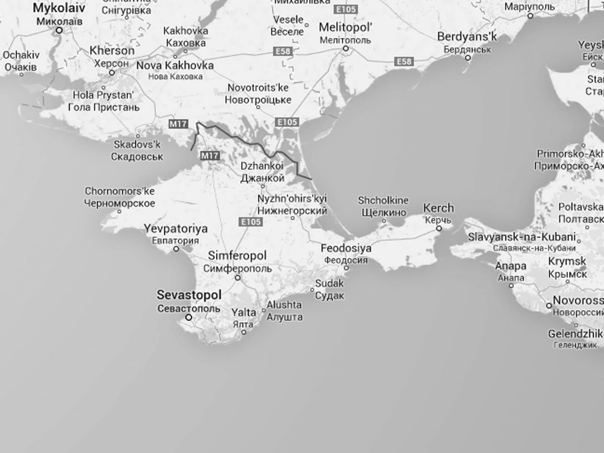
Crimea, as displayed on Google Maps in Russia, 2017. © Screenshot, Google Maps
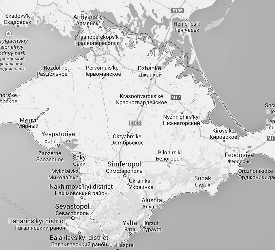
Crimea, as displayed on Google Maps in Ukraine, 2017. © Screenshot, Google Maps
That ease of use on the web eventually transferred to mobile, and Google Maps proved to be the crucial killer app of the iPhone. While it’s perhaps unreasonable to say that Google Maps and smartphones led to an entire generation never really developing a sense of direction, relying instead on the tiny blue dot hovering on their screens, maps did transform public movement. They also had an influence on commerce—why chance it with one of a handful of coffee shops in a neighborhood when you can go to the first one that Google Maps recommends? At some point, it became more important for companies to proactively make themselves legible to Google than for Google to seek them out.
The other technical shift of Google Maps might be misunderstood more as an aesthetic one. Around the same time that the company was assembling its maps team, it bought Keyhole—a CIA-funded mapping company that made software for viewing satellite imagery. According to a Recode article on the tenth anniversary of Google Maps’ launch, the decision to acquire Keyhole came when Sergey Brin interrupted another acquisition meeting to show off the software, declaring “this thing’s cool and we should buy it.”7 Executives were instantly thrilled by the software, and began yelling out their addresses so that they could see their homes from space. “If our mission is to make all the world’s information useful and accessible,” VP of engineering Wayne Rosing is reported to have said during the meeting, “then this is the real world.”
Prior to what would become Google Earth, civilian access to high-resolution satellite imagery was extremely limited by both monetary cost and technical expertise. Through Keyhole, Google literally created a new way for most people to see the world—and while it’s been normalized enough to be readily taken for granted, what a bizarre, beautiful way to see it. Brin was right: this thing is cool. I’ve personally lost countless hours to panning and zooming through the perpetual cloudless afternoons of the Google satellite basemap—jewel-like lithium fields, enormous satellite dishes like tiny moons in New Mexico, the dazzling order of container ports. But there remain blank or at least fuzzy spots on the map, usually due to negotiations with nation-states: high-resolution imagery of Palestine, for instance, is never available and probably never will be.
Another name often used by developers for tile maps is, quite satisfyingly, the “slippy” map. While the term references the map’s seamless pan and zoom effects, it also resonates with the political slippages between web and world that the maps, and the technology underlying them, enable. Cries of “Google Maps censorship” at territories erased or character encodings mangled assume that Google has some responsibility to truth or a public record, rather than to shareholders. Furthermore, it assumes that being legible in Google’s landscape is not only somehow a right, but a desirable outcome. But being a fixed point in the slippy map doesn’t afford individuals greater freedom of movement or any kind of diplomatic recognition. It merely distills people, places, and things into another piece of the world’s information made, or to borrow from Google’s mission, useful and accessible (to Google).
While platforms and smartphones were mapping the world in precise detail, transforming it if not in its own image then maybe in its aesthetics, maps of the internet—and particularly the internet as manifested in the world—were only becoming more illegible. Gone were the days of logical nodes and an internet so small that it could fit on a printed “road map.” All that can be learned from visualizations like the now-ubiquitous 2005 map of network connections by Matt Britt is that the internet is an unfathomably complex place, an infinite maze. The only way to navigate that dense complexity was via the platforms, which ranked, indexed, streamlined, and mapped the internet into pristine dashboards, news feeds, and eerily accurate product recommendations. Much as Google Maps and smartphones atrophied innate senses of direction, platforms atrophy the capacity for wandering through the web in search of questions and connections rather than instantaneous answers or desultory dopamine hits from the “like” button.
The tendency of users to remain in filter bubbles and propagation of myopic communities via platforms and recommendation engines has been well-documented, as has the tendency of these narrow environments to enable mass harassment, misinformation, and propaganda campaigns. In response, companies offer resources on media literacy and piecemeal hiring of content moderators or fact checkers. But placing the onus on individuals to season their news feeds with opposing viewpoints (rather than, say, designing a platform optimized for bringing multiple viewpoints to users) or assuming the issue is the ability to critically discern sources (rather than recognizing that many users are entirely media-literate but happen to hold racist or fascist beliefs) suggests platforms consider power something that the invisible hand of the market has clumsily pushed them into against their will, and not something abused in the absence of a meaningful praxis. Furthermore, it assumes that greater legibility of a user and their nuanced perspectives is a desirable outcome. Users have the agency to reshape the territory of their digital bubble, but they remain mapped subjects.
There is some irony to the mapping impulse of platform companies, insofar as they largely emerge from landscapes historically willfully in denial of their own spatial confines. As a place in public imagination, Silicon Valley is more often defined by its companies than its geography. This, in part, might be ascribed to the particular way most tech companies inhabit these suburban cities on the San Francisco Bay Peninsula: on campuses, enclaves set apart from the day-to-day of the cities they inhabit. To claim that Facebook has “offices” in Menlo Park doesn’t really do justice to the experience of driving along its particular expanse of the Bayfront Expressway where its (former Sun Microsystems) compound and its Frank Gehry–designed expansion loom in the distance. Today’s platforms inherit a landscape architecture and urban planning approach pioneered in the 1950s and 1960s. The corporate campus and suburban sprawl is not an invention of Facebook or Apple so much as the natural habitat from which their particular worldview might emerge. No landscape could inspire the dream of the autonomous vehicle more than traffic on the southbound 101 trying to make the Moffett Field exit.
What has changed since the dawn of the corporate campus is the movement of companies to make their campuses more like towns, and more active participants in the construction of the urban environment. Google has been in a years-long negotiation with the city of Mountain View to help develop nearly 10,000 new homes (in exchange for yet more office space). Facebook had contributed $600,000 to Menlo Park to construct a top-of-the-line new police substation down the street from the company’s offices in 2014—a development that the city’s police chief Robert Jonsen described as “setting the standard of public-private partnerships.”8 In July 2017, the company announced plans to build out 1,500 residences and a retail district for the “Willow Campus” adjacent to their current compounds in Menlo Park.9 Reports describe these efforts as Facebook trying to be a “good corporate citizen,” showing more responsibility to that “community” that Zuckerberg is so fond of speaking about.10 Never mind the fact that meanwhile, Zuckerberg’s philanthropic arm, the Chan-Zuckerberg Initiative, has been displacing trailer-inhabiting residents of East Palo Alto, the town right on the border of the Facebook campus, in order to construct a charter school.11
As platforms grew, so did their needs for computing power, energy, water, and their real estate footprint. This, too, was obscured in maps. For years, I heard rumors that Google actively removed their data centers from Google Earth. I only ever saw two screenshots that suggested that possibility might be true, so I remain skeptical, but as fable it fits well.12 One of the most ingenious details of Google Earth was its compositing of historical satellite imagery to create a picture of the world from space with zero clouds. Of course the company would want to also scrub out their own cloud computing. The world in Google Maps is a world of effortless slippage, and to see the weight of material infrastructure that makes that slippage possible would destroy its magic.
But if this fable was ever true, it likely isn’t now: today, searching for Google data centers on Google Earth is as easy as searching for your own house. Google and Facebook both publish glamour shots of their data centers, shifting them from trade secrets to PR props on which charming murals can be painted and carbon offsets can be applied. While this outward-facing shift may be in part due to the realization that hiding giant buildings mostly located in the middle of nowhere is slightly pointless, it also reflects an understanding of the role of platforms as increasingly foundational communications and information infrastructure. Showing off their actual infrastructure might inspire confidence, or awe, or fear, or all of the above. Google and Facebook of course aren’t alone in this—recall Jeff Bezos standing atop a wind turbine to celebrate Amazon’s efforts to cut down its carbon footprint—but they are perhaps the most prominent figures.13
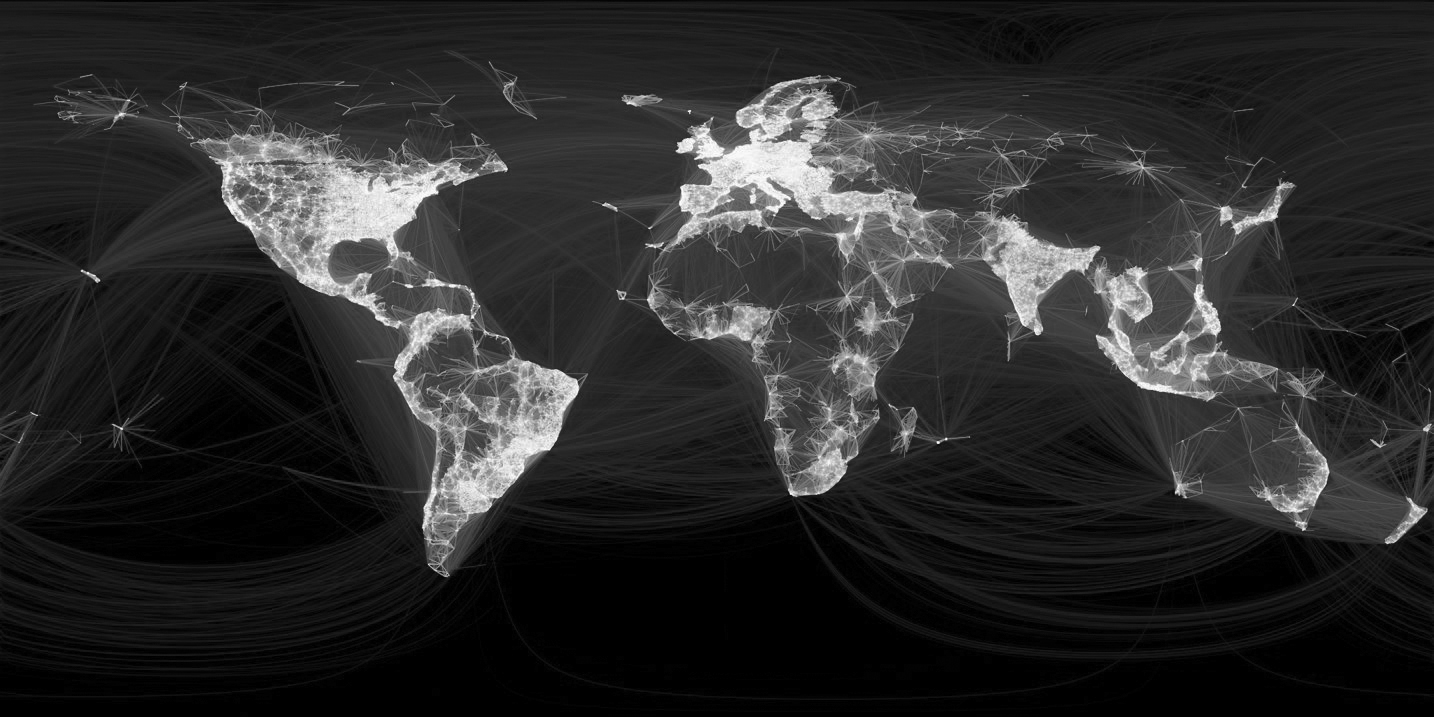
*Visualization of ten million relationship connections among Facebook users, 2017. © Facebook
Eleven years after teenage Mark Zuckerberg built out a web of his peers in a Java applet, an engineering intern at Facebook produced a visualization of ten million relationship connections among its users, geographically plotted and connected with arcs. The resulting image provided a startlingly close outline of a world map. An updated version of the visualization in 2017 showed an even more detailed map, with east Africa and South America filling in quite nicely. Fifteen-year-old Mark’s web shows no sign of diminishing. Facebook’s visualization of global connections is a pure mappa mundi: it’s useless for wayfinding and not even particularly illustrative of how relationships across the network actually work. When isolated from the image of the whole, the mapped relationships reflect dense pockets of pre-existing ties and diaspora connections, rather than the composite image’s gossamer strands connecting strangers and making neighbors of nations. But as propaganda serving a vision of Facebookistan as a united global community, it’s perfect. A world without Facebook would be a world of total darkness; a disconnected web and a collapsed society (or maybe just a world that’s a little more like the obviously absent China).
This is, perhaps, where the SEZ comparison starts to become more obvious and pernicious: not only are Google and Facebook too big to conceal their infrastructure, they’re also too big to fail. No matter how many moral or potentially illegal transgressions platforms enact, their quarterly earnings statements dazzle. No matter how much users complain about how much they actively dislike the platforms, no matter how cognizant they are of the manipulations to the timeline or the map (either algorithmically or geopolitically), they remain users. No matter how egregious the harms, governments will at best fine these multi-billion dollar platforms somewhere in the tens of millions and generally treat regulation more as a question of “which superpower should moderate public speech” instead of “is this business model fundamentally toxic for public speech.” At some point, it became easier to imagine the end of capitalism than the end of the network.
The compacts between platforms and users afford the latter little political power or agency in these increasingly overlapping zones. Maybe we’re more like embittered indentured employees or squatters on the fringes of an SEZ. The maps made by platforms—of themselves or of the world which they increasingly reshape in their own image—will never offer their users convenient escape routes.
That being said, transgression, rebellion, and personal expression can and does still take place within and around the margins of the platforms. A sovereign is only ever as stable as its underworld, and it’s worth asking whether recent manipulation of platforms to propagate misinformation and hate speech is an example of transgressive use, or the platform working exactly as it was intended. Like most spaces of transgressive exception, some blank spots on the map exist in part due to the benevolence and discretion of other powerful actors (lest we forget that the Tor Browser wouldn’t exist without the Naval Research Lab and the State Department). But remaining on the imagined fringes of the network might only afford us the kind of freedom Barlow opined for in 1996: the convenient imaginary of outlaw cyberspace, the wild frontier in which white men can always mean well while moving fast and breaking things, or where the privileged prepper can build her own infrastructural enclave apart from the platforms, but remain no less complicit in isolationism.
In an interview on the occasion of the twentieth anniversary of his declaration, Barlow lamented to The Economist that “Over the decades, it has been continuously fashionable to make a straw man of my declaration, to hoist it up as the sort of woolly headed hippie nonsense you’d expect from techno-utopians like me.”14 Perhaps then it is more constructive to expand upon what even Barlow admits was a glaring absence in his declaration: in that same interview, he noted that had he a chance to revise the document, “I would make it more obviously clear that I knew that cyberspace was not sublimely removed from the physical world,” and therefore, to some extent, beholden to the laws of governments that maintained its infrastructure.
Indeed, the so-called immateriality of the internet—a vision popularized in its maps and the gaps on it—is perhaps the greatest source of plausible deniability for earnest CEOs invoking community and empowerment while enacting complicity and arbitrage. The forums and platforms on which we shop, share, and protest, and the nation-states within which we pay taxes, vote, and protest, have always been in a state of misunderstood entanglement: never really separated by false dichotomies of IRL and online, always inserting spooky actions across the distance of fiber-optic cable and wireless transmissions. As effortless slippage becomes context collapse, as revolutions give way to propaganda campaigns give way to ethnic cleansing, it becomes harder and harder to escape the feeling of slippage as freefall.
The geographies and architectures that networked platforms actually inhabit—their corporate campuses, data centers, water lines, power grids, submarine cables, and company towns—are distillations of those entanglements, the most heavy-handed options for material manifestations of Facebook or Google’s so-called borderless empires. Rather than merely finding pockets of freedom in the networked SEZ archipelago, it is high time to go on the offensive—not only constructing alternative infrastructure, but mapping, sabotaging, and expropriating theirs.
-
John Postel, “Request for Comments 1591: Domain Name System Structure and Delegation,” March 1994, https://www.ietf.org/rfc/rfc1591.txt. ↩
-
John Perry Barlow, “Declaration of the Independence of Cyberspace,” 1996, https://www.eff.org/cyberspace-independence. ↩
-
Richard Vilgen, “Deleted City,” 2017, http://deletedcity.net/. ↩
-
Hacker News. “Mark Zuckerberg’s first website is still on Angelfire,” April 3, 2013, https://news.ycombinator.com/item?id=5486014. ↩
-
Casey Chan, “Holy Crap, Is This Mark Zuckerberg’s Embarassing Childhood Angelfire Website?” Gizmodo, April 3, 2013, https://gizmodo.com/5993535/holy-crap-is-this-markzuckerbergs-childhoodangelfire-website; “Mark’s Homepage.” Archived April 4, 2013. https://web.archive.org/web/20130404151448/http://www.angelfire.com/ny/mez51/. ↩
-
Rebecca MacKinnon, Consent of the Networked: The Worldwide Struggle for Internet Freedom. (New York: Basic Books, 2012). ↩
-
Liz Gannes, “Ten Years of Google Maps, from Slashdot to Ground Truth,” Recode, February 8, 2015, http://recode.net/2015/2/8/11558788/ten-years-of-google-mapsfrom-slashdot-to-groundtruth. ↩
-
Cyrus Farviar, “Facebook-funded Silicon Valley police station, with free wi-fi, opens,” Ars Technica, April 26, 2014, https://arstechnica.com/tech-policy/2014/04/facebook-funded-silicon-valley-police-station-with-free-wi-fi-opens/. ↩
-
George Avalos, “Facebook campus expansion includes offices, retail, grocery store, housing,” Mercury News, July 7, 2017. http://www.mercurynews.com/2017/07/07/facebook-campus-expansion-includes-offices-retail-grocery-store-housing/. ↩
-
Jessica Floum, “Facebook proposes campus expansion, pledges millions to Menlo Park,” SFGate, July 15, 2017, https://www.sfgate.com/business/article/Facebook-proposes-campus-expansion-pledges-8381447.php. ↩
-
Nellie Bowles, “Facebook Founder’s Favor Comes With Complications,” New York Times, November 23, 2017, https://www.nytimes.com/2017/11/23/technology/mark-zuckerberg-housing.html. ↩
-
One incident documented by the author in 2015, the other by Andrew Blum in 2012: “Google’s famed mission statement is ‘to organize the world’s information and make it accessible and useful.’ Yet at The Dalles, they’d gone so far as to scrub the satellite image of the data center on Google Maps–the picture wasn’t merely outdated, but actively obscured.” Andrew Blum, Tubes: A Journey to the Center of the Internet (New York: Ecco, 2012). ↩
-
Jeff Bezos, “Fun day christening Amazon’s latest wind farm. #RenewableEnergy,” Twitter, October 19, 2017, https://twitter.com/jeffbezos/status/920999561564274688. ↩
-
“How John Perry Barlow views his internet manifesto on its 20th anniversary.” The Economist, February 8, 2016, https://www.economist.com/news/international/21690200-internet-idealism-versus-worlds-realism-how-john-perry-barlow-views-his-manifesto. ↩